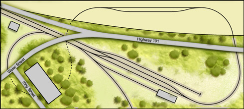
As the benchwork progresses I’ve had some time to test some 1:1 track planning and I’ve been making small modifications to the plan. I decided that I would stay from the prototype in favour of a slightly more operational yard. Granted ‘ the yard is small ‘ but isolating yards movements from the mainline will be advantageous. One of the benefits is that the track itself ‘looks’ more like the prototype, even though it’s not the same.
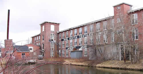
Likewise, a suggestion was made by a reader that I consider including the now-defunct Nova Scotia Textiles building. While I cannot pinpoint the exact location of the mill, I do know it resided on King St., overlooking the Windsor yard ‘ so for the time being I’ve included it as part of the design. I’ve had difficulty finding any images of the mill, so if anyone can direct me toward any images I’d be thankful!
0 thoughts on “Trackplan Tweaks”
Scott says:
I’ve zapped off an email to a couple friends of mine in N.S. Hopefully they’ll be able to help you out.
Scott
Ric says:
Actually I am one of Scott’s aforementioned friends. NS textiles is on the other side of Highway 101. Ever since the 101 went through it was never directly served by the RR. I’ll have to look through the rest of the stuff to see what I can help you with.
Model Railroader says:
Grumble… why can’t the prototype more accurately fit my baseboard (re: wrong side of highway ) 🙂
At this point I’m just looking for a few images of the building/area so I can produce a reasonable facsimile – or a decent homage.
Thanks!
Ric says:
Sorry about that. I don’t know how P/C you want to be but here are two tidbits of info that will help on scenery and maybe ops.
Looking at the latest trackplan Highway 101 on the right hand side crosses over the main after the tracks have gone back to a single mainline. Scenic block for disappearing tracks. Send me an email and I will dig up a photo for you that I took from the overpass looking back at the yard from opposite direction
The topmost siding is actually a scale track for weighing the gyp cars.
I also noticed in one of the other entries on here you were wondering about the spurs on the bottom of your trackplan. The one on the left is what remains of the old mainline when it cut through town before the causeway was built heading down the rest of the valley. The one on the right connects the WHRC with CN in Windsor Junction.
Model Railroader says:
Thanks Ric!
Mike G says:
This version of the WHRC track plan is very nice and instantly recognizable to me! Nice going! 🙂
What are the dimensions?
-mike
former Valley resident